The IOTF is the Working Group on obesity in the world, which has been investigating for decades this serious health problem in so many places. On its website we can find the map of childhood obesity in the world, and also of adults, which indicates which countries are more prevalent and which ones do not have this problem.
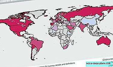
It is an interactive map in which we find the relevant data of each country affected by a high rate of obesity if we click on them.
As we see, continents such as Europe or North America appear almost completely dyed in the "dangerous" colors, and in these places obesity and overweight constitute a serious public health problem as we have commented so many times.
Since the end of the 70s, the international criteria of overweight and obesity in children proposed by the IOTF, which were developed from the databases of six countries.
This body estimates that in the world 200 million school-age children are overweight (2010 data), and of them 40-50 million are obese. In the European Union there are 12 million school-age children who are overweight (overweight or obese). WHO also collects data on obesity in the world, of which we have recently spoken.
The current state of excess child weight in the world is collected on the map that we observe on these lines. It is a global problem, of which virtually only the poorest countries in the world are saved.
Even in developing countries obesity begins to be a problem in urban environments while, paradoxically, in other areas of those same countries people go hungry.